


GeoSmart Monitoring Tools
GeoSmart Monitoring Tool is a powerful software tool for geotechnical monitoring data management and data reporting. You will find handling a big monitoring project is so easy with the software tool.
Key Feature of the Program:
Easy to handle the project related like location plan, installation details and soil condition of monitoring point.
Organize and handle the project information and monitoring data by project, zone, reference point and monitoring point.
Smart data entry system.
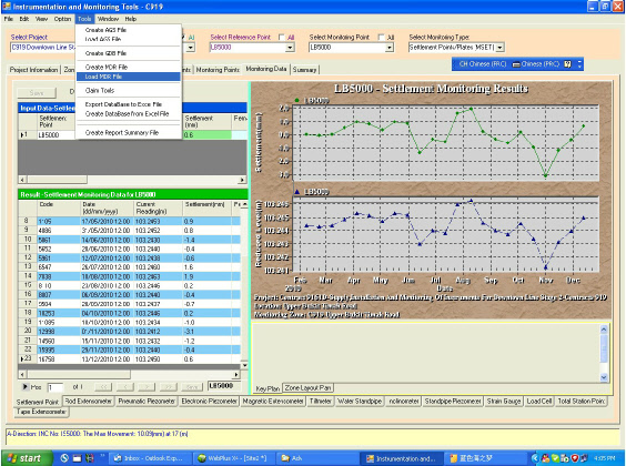
Calculation formula built in the program, all the monitoring data curve will be automatically calculate and show by the program after data entry. Flexible data entry, user can key in the daily monitoring data in an Excel file (All types of monitoring points in a Zone). And load the data to the monitoring database by one click.
Monitoring Type:
Settlement point, Rod Extensometer, Pneumatic Piezometer, Electronic Piezometer, Magnetic Extensometer, Titlmeter, Water Standpipe, Inclinometer, Standpipe Piezometer, Strain Gauge, Load Cell, Total Station Point, Tape Extensometer.
Flexible Drawing View and Output:
Build in graph tool to show the monitoring data, the scale, legend and axis can be customize by user. Graph window can view in full screen, zoom in to show the data curve in details. The monitoring graph can export as an image file directly.
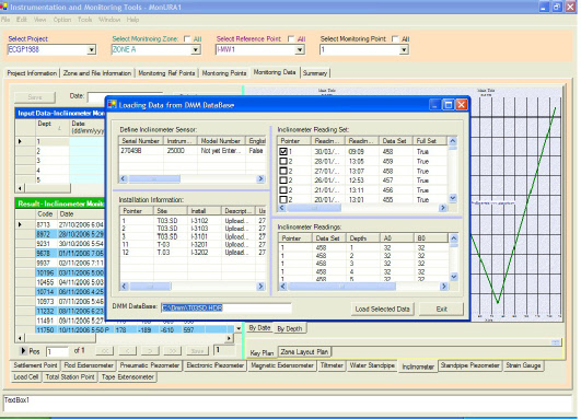
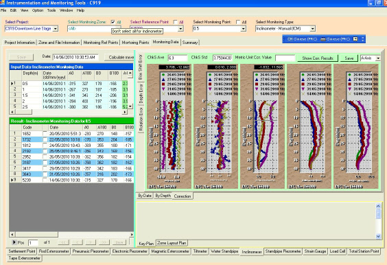
Powerful Software Tool for Inclinometer Monitoring:
Load Inclinometer data directly from inclinometer data files. Suitable for Sinco and Geokon equipments of data files. DMM files( .PRN, HDR, .MDB) .txt files and Excel file. Load the data for all instrument points at one time. Attached Smart Check Sum Analyses Tool. Output functions: Print data & chart: Design the output scale and selected the dates to report, print out the graph and output the data in Excel file.
Data Transfer Tools:
Create AGS file by select project, zone, monitoring point, date. Load AGS file to communicate with client side and update the database daily. GeoSmart AGS format include Graph chart information. Create GDB file for LTA Project.
Powerful Claim Tools.
Instant Data Summary:
Create instant monitoring data summary table.
Select any three date to generate the date summary for select project or zone.
Set warning rang.
Data Analyze Tools for Inclinometer:
Depth Error Correction Tool.
Rotation Error Correction Tool
Bias Shift Error Tool.
Download Report Sample
Download Product Brochure